Originally, this was to be a blog about my preparations to enter the TGO Challenge in 2012. For a variety of reasons that didn't happen, so this has now become the repository for my outdoor musings.


Tuesday 31 July 2012

The Cotswold Way - Part III

I had hoped to knock the Cotswold Way off over the winter and spring. For a variety of reasons this didn't happen. Weather, time, moving house: excuses I know, but valid ones!

One of the perks of moving is that our new house is only about a ten minute walk from the Cotswold Way, so this leg would actually be walking home (and rather splendidly the next leg will start from my front door!)
Last Wednesday I set out at about half seven to walk up to the main road, where I would catch the number 46 bus to the outskirts of Cheltenham. Rendezvousing with Chris, my walking buddy for the day in a pub car park (strangely prophetic of the day ahead) we drove up to my finish point from the last leg. Sadly, roadworks meant the road up the hill was closed so we had to park much lower than we wanted to. This added an extra couple of ks to our day, but seeing as it wasn't going to be too strenuous we grinned and bore it.

This particular stretch, from Leckhampton to the outskirts of Cranham, was fairly wooded, which in light of the hot sunshine was well received by us both.


Skirting around Leckhampton Hill we picked up where I had previously left off and wended our way towards Crickley Hill.

Looking West from Crickley Hill

We availed ourselves of the ice cream purchasing facilities at the small but interesting visitor centre before pressing on. Shortly we came to the most unpleasant bit of the Cotswold Way so far.

The A417 runs below the trees before heading up and over the horizon.

The A417 has to be crossed, and then you walk up the hill alongside the nose-to-tail traffic for a few hundred metres before you can peel off in to the fields again. The crossing is a real life-in-your-hands moment. Yuck. Nestled in the elbow of this exceptionally busy junction is the Air Balloon pub. We were early so it was shut, but frankly I cannot understand why you would want to stop here.

Looking back at Crickley Hill


 We pressed on towards Birdlip through most pleasant woodland.


Most Pleasant woodland.

Below Birdlip we spied some crags tucked away in the woods. Always on the lookout for new climbing spots Chris peeled off left for a look. Sadly our hopes were dashed. We realised that what had on first glance looked like an exciting little spot to while away a few hours was in fact a chossy death-trap! The stone was flaky and hollow sounding with scarcely anywhere to put pro. If you did manage to get off the ground you ran the very real risk of pulling down tonnes of loosely stacked rock on to you and you foolhardy belayer.
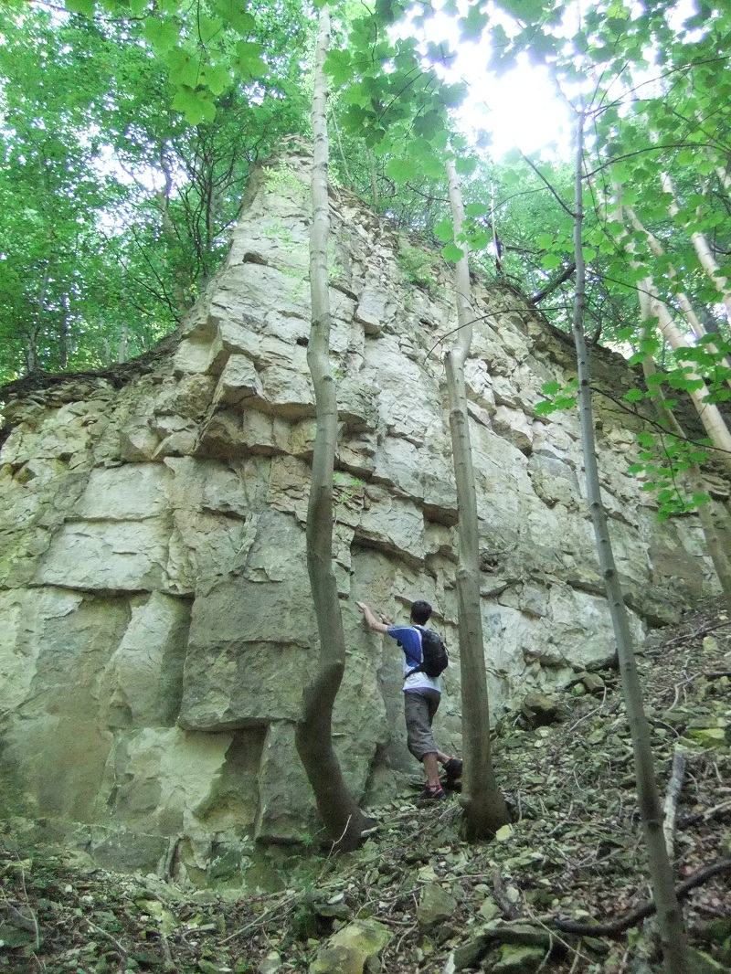
Optimism

We gave it a miss and headed on. To console ourselves we headed up to the village of Birdlip where by happy chance we found the Royal George. As it was only just 11 (ahem) we had the place pretty much to ourselves. We ordered some beer, and a couple of ciabattas. We were momentarily perplexed when the barmaid asked Chris how he would like his chicken cooked. He decided on "Thoroughly".


After we had rested and aired our feet for a bit we decided we must press on. We dropped back down the hill and picked up the well waymarked trail again. 


Easygoing

Catching lovely views of our route so far we strolled through the woods on our way towards Coopers Hill. If you have ever seen footage of the charming English custom of cheese rolling, this is where it happens. It is a very steep bit of hill, and the Cotswold Way passes below it and then, after a painfully steep climb, the top of it.


Looking down the cheese rolling slope.

A couple of notes here. As you come out of the woods below Coopers Hill, the Harveys Cotswold Way map shows a cafe. Whilst we saw the building and the signs, it certainly didn't appear to in use any more, so don't count on it. A further point is that the waymarking post at the top of the hill points towards two fairly close paths. We took the left hand one which as it turned out was the wrong one. Go right! After a brief and not unpleasant detour we were soon on the right road, and headed on through the woods towards the A46, and the Royal William.

Further refreshment was taken here, before we dropped back down to my place after a very relaxing twelve mile stroll along the edge of the Cotswolds. 

The next leg will start taking me in to unfamiliar territory. Hopefully not such a long break between updates!

Chris, I hope you don't mind but I nabbed a couple of your Instagram pics..?

Sunday 1 April 2012

Inov8 Terroc 330 stitching

Nearly a year ago I bought some Inov8 Terroc 330s. This was going to be quite a departure for me, as I'd always used boots for hill and mountain walking. Browsing blogs and reading tales of lightweight derring-do seemed to indicate that this was the way forward. My only previous experience of "hiking" trainers was with a pair of TNF Hedgehogs which destroyed my feet on a charity walk back in '09 (Linky) So it was a bit of a leap of faith.

I loved them! A three day backpack in the Cairngorms, walks in the Brecons, on the Cotswold Way, occasionally on the bike; they were great. Cool and light obviously, but with the extra benefit of connection to the ground. Very often I find myself stumbling when wearing boots as my feet are "stiff" and heavy. With trail shoes this was no longer a problem. Foot placement seemed much more precise, and I didn't miss the ankle support, or weight, of my Scarpa ZG10s (good boots, and lightish for what they are, but still twice the weight of the Terrocs).


Sadly the "Curse of Inov8 Stitching" struck. Despite what I would consider to be fairly light use, the stitching on the outside edge of the shoe ripped. Casting about online it appears that this is not uncommon on Inov8 footwear. What to do, what to do? Well, I'm not flush enough to write these off and drop another £90+ on a different brand, and to be honest, I would expect a premium product, designed for offroad use, to last better. I mean, I had a cheap pair of Nike trainers that I used for work everyday for a year nearly, to the point where I had worn the soles through, and the uppers were still together!

So I emailed inov8, who said my first port of call should be the retailer. So I popped in to Up and Running in Cheltenham, who said they would see what they could do. A week later I got a call saying inov8 would replace the shoes, and four days after that they were in the store.

Following the advice of Colin Ibbotson (@tramplite on twitter) I seam-sealed them immediately when I got home, hoping that this might protect the stitching, and prolong the life of the shoe. Watch this space!


So, many thanks to Up and Running, and to Inov8 for good customer service. I would be interested to hear about the success or otherwise of seam sealing shoes. Please leave a comment.

Monday 23 January 2012

The Cotswold Way - Part II

In my previous post, when I said sometimes it's right on your doorstep, I wasn't kidding. This morning I walked down to the main road, caught the 606 to Winchcombe (cost £2.10) and ten minutes later was setting off up the hill towards Belas Knapp. It was very convenient.


Chasing The Acorn


As before, I'm not going to go over the route in great detail, just point out some of my observations that may be helpful to those following in my footsteps.


Interestingly, although the weather has been mild and unsettled, the going under foot was generally very good (apart from one section which I'll come to shortly). Very rarely was the ground slippery, more often than not I could feel the lugs of my Inov-8s biting into the surface. Probably the worst section overall was across the top of Leckhampton Hill, which had caught the rain a bit more heavily than the rest of the route. On top of a very hard base there was a centimetre of slippery mud that was pretty treacherous.

As before, route finding was very straightforward. The Cotswold Way is well signposted and the path was clear to follow. My only beef would be that occasionally the route loses hard-won height for no discernible benefit. I think the worst example of this is on Cleeve Hill. Cleeve is the highest point in Gloucestershire at 330m, and although the path doesn't quite hit that high point, it's not far off. Yet as you head south towards the three distinct radio masts, the path drops down the side of the hill. This section is quite pleasant, but then you enter the Bill Smyllie Butterfly Reserve and things become less so. Initially this isn't too bad, but then you climb and the path leads you through a narrow valley, the bottom of which gets chewed to hell by horses and cattle. It's lined with thorny trees, there's no view and the going underfoot can be abysmal. I had the misfortune to cycle through here when it was particularly wet and it was truly, truly horrid.


The Valley of  Death

What make this particularly galling is (1) you're going to need your hillclimbing energy later on, and yes, I am looking at you Lineover Wood and Wistly Hill, and (2) you can bypass it very easily. If you want to do as much of the official route as possible, then carry on in to the butterfly reserve, but rather than heading in to the valley, climb up to the left and follow the clear path until you merge once again with the route. If you would rather not lose too much height, then instead of dropping off to the right before the radio masts, continue on to them. Go through the gate and walk about 200m along the road until you come out of the trees, where you should spot a small gate on your right. Through this into the butterfly reserve, stay above the small copse and again, aim above the valley for a much better path.

For those of you interested in the hostelry potential of the route, and I know there are some of you out there that will be, this is going to be a tough section. In fifteen miles today, I didn't go through anything that could be described even as a hamlet, so shops and pubs were thin on the ground. Don't completely give up hope however. On top of Cleeve Hill there is, bizarrely, a golf course. And where there are golfers, there will be a clubhouse. And this clubhouse is open to the public. It advertises hot and cold food and drinks, so could be worth a stop. I can't vouch for quality as I didn't stop, but beggars can't be choosers. A little further on you can drop down to the road to the Rising Sun which is an oddly named pub, facing west as it is. Again, I didn't stop as the climb back up to the route is pretty gruelling. Next, the Harveys map shows a pub close to the crossing of the A40, bad news, it's not a pub. The Reservoir Inn has had many changes of ownership over the years, and it's never really thrived. It's now an Indian restaurant called Koloshi which could be good but probably isn't going to be the long-distance walkers first choice, if indeed it's even open as you pass.Then you've got the pub at Seven Springs. I'm not going to link to it, as I don't particularly like it. I have found the staff to be disinterested, the place grubby and the food very average. It's one of those "big plates of unexceptional food" type of pubs. Your choice. And that was it for pubs. It's ironic really as for large parts of the day you're looking down on Cheltenham and environs, a town crammed with exciting opportunities for revelry!

If you're camping, there are places that would hold a tent, although I would add that Cleeve and Leckhampton in particular are very popular with the local cyclists/walkers/dog walkers/power kiters/horse riders, so you may need to hunt around off the beaten track.


I can (honestly) see my house from here...

It was an interesting days' walk: Cleeve and Leckhampton Hills are places I know very well, having walked and cycled over them a great deal. Linking them together as part of a longer route is a different experience and involved seeing them in a totally different way.

In total, I reckon I've done somewhere in the region of 35 miles in my two walks, so I'm about a third of the way to Bath. 

Keep posted for the next thrilling instalment!


Monday 17 October 2011

Sometimes, It's Right on our Doorstep


It can be very easy to dismiss the familiar as mundane. I confess to having done it. If I have a day clear when I can head for the hills, do I look out the window at the local countryside and think “Yep, that’s what I want to do” or do I get my maps out, pull the guide books off the shelves, fire up Grough and look for something challenging, steep and rocky? Clue: it’s the second one. The reasoning seems to be that unless it’s toughish and mountain-shaped, then it’s not really going to give me what I need. The adage “Familiarity breeds contempt” fits here, although it’s not really contempt, more ambivalence, an existential “meh”.

Well, last Friday, I learned my lesson. I set off on what turned out today one of the finest days walking I have had in a very long time. It was no epic, there was no packraft, no rucksack stuffed with a month’s food or wading through thigh-deep swamp. The weather was glorious, my physical altitude peaked at around 320 metres, but my emotional altitude was way higher. So what did I do?

A little background information first. I moved up to Cheltenham, Glos., in 1996, and aside from a few years living in Ross-on-Wye after I got married that’s where home has remained. Cheltenham markets itself as “Centre for the Cotswolds”. Note the for in that slogan; it’s not in the Cotswolds, it’s on the edge, down on the Severn plain. Nonetheless, from my window as I type this I can see the Cotswolds. The escarpment arcs around the eastern edge of Cheltenham, so I can see Cleeve Hill to the north and follow the sweep that takes in Wistley, Leckhampton and Crickley Hills. I’ve strolled about on the their slopes, I have ground up and flown down their twisty trails on my mountain bike. But I have never viewed them as a destination for a hillwalking day. In fact the Cotswold Way has always struck me as a bit red-socked rambler, a bit “Country Walking”, a bit, dare I say it, Julia Bradbury...

Interestingly, as I have got older, I think I have become more prepared to reconsider my opinions. Naturally, we make decisions very quickly on what we see or hear, and we base our actions on those judgements. It is really important to remember that they are just that, snap judgements worthy of further, deeper consideration. And this is what happened with me and the Cotswold Way. Looking for a project to keep me occupied over the winter I thought why not do the Cotswold Way in stages. It passes no more than three kilometres from my house, it seems churlish to ignore a 105 mile long, waymarked trail that’s right on my doorstep. I bought the Harveys Cotswold Way map (also another first, having always been an OS loyalist) and looked over the route. Game on.

So this Friday just gone, Bev dropped me of in the middle of Chipping Campden at the northern end of the route. It’s a pretty little town, but I didn’t linger. I was heading for Winchcombe, 30 kilometres and a days walk south.

The Start

Now, I am not going to give a blow by blow description of the route; there are plenty of maps and guide books that will do that for you. I thought I could just mention a couple of highlights, and maybe list some observations that might be helpful to those following in my footsteps.

The Mile Drive

One of things that struck me was how big Cotswoldian sky can be. The top of the hills can be very flat, and on a beautiful day the canopy of the sky seems immense. Although you are never far from a road, the vertical space makes up for the slightly constricted horizontal.

Something else that you cannot help but pick up on is the age of the landscape. When you walk the wild parts of Britain, very often it is easy to imagine that all human life has disappeared. Would that landscape look any different if that were the case? Not much. Yet the Cotswolds are different. They feel ancient. And there is a good reason why this is the case. They are ancient. A quick glance at an OS map shows earthworks, forts, barrows and settlements. Roman roads, villas and ruins dot the landscape (Bath, the terminus of the Cotswold Way is probably the most famous Roman site in Britain). That depth of history permeates you as you walk through the landscape. You seem to soak it up through your feet until you are brimming over with it. It’s hard to describe, it’s definitely worth experiencing.


A good crop of Cotswold stone coming on.

Fairly straightforward navigation at this point.

The Cotswold Way also passes through what must be some of the most quintessentially English countryside you could imagine. It crosses the high, flat tops of the hills before dropping down through little valleys to freakishly charming Cotswold stone villages (some of which are yet to be overrun by camera-wielding, tat-buying tourists). Winding across park-like fields, it suddenly climbs steeply, opening up beautiful vistas to the west. It is very pretty!

Stanton, home of the Mount Inn

I thought I might list here a few observations that may help those who are thinking of doing the Cotswold Way, perhaps backpacking it.

The route is ridiculously well signposted. Every junction, or direction change either has a finger board pointing the way or a little yellow “Cotswold Way” (with acorn) confirming the route. On longer stretches through fields or woods where there is no direction change a wooden bollard guides you onwards. I only used my map to see how far away the next stop was, I don’t think I used it for route-finding the whole day. If visibility was really, really bad it might be an issue.

The paths when I walked this section were in very good condition. They were varied (narrow, wide, stony, smooth, grassy) but firm under foot and easy to follow generally. I imagine after rain or a prolonged wet spell that may not be the case, I know from experience that they can get very slippery. I suspect I will confirm that as I continue walking the route over the winter.


One thing that struck me was the fact that on a couple of occasions the route leads you off the high ground to run you through towns like Broadway and Winchcombe. This is handy if you need to re-supply or make use of a hostelry (more on that in a moment) but it feels a bit contrived. If you don’t need to visit them, then these towns can be bypassed and a more logical route picked, although I guess that means you are not walking the Cotswold Way proper.


If you’re backpacking, it should be possible to find a somewhere to pitch up, if you are sensible. The route passes through woods and spinneys, and quite a number of the fields are very rolling. A low-profile tent or tarp, in a muted colour, pitched late in the day could well go unnoticed.


Normally I like to take in a mountain when I go walking. There are no mountains to be had in Gloucestershire so I had to settle on the Mount Inn in Stanton instead. It’s very slightly off the route, back up a short steep climb, but it’s worth a stop. Good beer, good food and ample beer garden to enjoy it in. Other hostelry stops could include Broadway and Winchcombe. There’s no shop in Stanton, so the only other resupply point would the shop at Hailes Abbey which has a small selection of drinks and sweets.

Stanway House

I hope that is of some interest, there will be more information posted as I work my way south over the coming weeks. I never really gave the Cotswold Way much credit, but my eyes have been opened and I am thoroughly looking forward to the miles to come.

Monday 19 September 2011

Seven Of One, Half A Dozen Of The Other.

September rolls around and a young/middle-aged/old man/woman's thoughts turn to the TGO Challenge entry form. There it sits, taunting or tempting you from the back of September's TGO. For some, there is no hesitation; they fill it in, write a cheque for £30 and send it off post-haste to John Manning. Others dwell on their entry; maybe they've never done the challenge and are apprehensive about whether they are up to it, or maybe they did it last year and never want to go near it again! Of course, there are the Challenge Old-Timers, not necessarily that old, but veterans of many a crossing. The Challenge for them is an opportunity to be in a place they love, doing something they enjoy, with like-minded, whiskey-drinking chums. I leave it you to decide which camp you fall in to.

What camp do I fall in to?

Well, I'm 42, so I obviously fall in to the "Young Man" category. And I've never done the challenge, so I think I fall in to the "Apprehensive" section too. I am also going to fall in to the "Not Posting an Entry Form In" category.

It feels a bit strange, and final, to type those words. The decision not to enter next year's challenge has been both tough and simple to make. "Explain please" I hear you ask. I will.

It's tough because I love Scotland. I have not visited or walked there as often as I would like, and the Challenge seemed like a perfect opportunity to spend time in a wonderful environment. I have also come a bit late to the backpacking/wild camping aspect of enjoying the outdoors and a chance to test myself doing it is one I really wanted to take. Of course you can't discount the opportunity to by new, lighter, shinier kit, and this is a major driving force in too many of my hobbies. So many things in the Plus column...

If I love all these things so much, then why am I not entering? As I mentioned in a previous post, I really miss my wife when I'm away, and two weeks is just too long. Even if she came up and met me a couple of times I'm not sure that would help. I'm self-employed so we don't always find it easy to take weeks off for holidaying purposes, so for me to take two weeks off and spend it doing my own thing seems a bit selfish. That also links to one of the more mundane reasons to not enter: wonga. Taking two weeks off, during these straitened times, just isn't going to be practical. I thought I had made my mind up that I wasn't going to enter, then the entry form turns up and I go back to planning, thumbing through guidebooks and browsing blogs, but ultimately, in my heart of hearts I just knew it wasn't going to happen.

So where does that leave me, in the hiking/backpacking scheme of things? Is this The End of my backpacking dream? Well, no. I need something to aim for, some reason to keep my fitness levels up over the winter, some excuse to buy that vital titanium-carbon fibre aglet, and some challenge to look forward to. So, to that end, I have been casting about for something to do, and I have found it. I won't go in to details here just yet, but suffice to say, I'll be away from home for just four nights, I'll miss only three days work, I'll walk 100 kilometres and climb over 7400m. Maps have been bought and routes plotted on Grough, Chris and Pete have expressed their interest in joining me, so wheels are creaking in to motion.

So there it is, I am genuinely sad that I won't be entering the Challenge next year (although never say never). However, deep down, I know it's the right thing to do.

(Of course not entering does make a mockery of my site's address, and my Twitter handle, @KenTGOC2012, but I'm hoping you'll all just over look that...)

Wednesday 24 August 2011

A Last Wild Place

I have just finished reading this excellent book by Mike Tomkies and can thoroughly recommend it to anyone interested in Scotland, the Highland flora & fauna and preservation of wilderness. I don't intend this to be a book review so you'll have to find a copy yourself and read it! I found that his thoughts from the last couple of paragraphs struck a chord, and here they are:

"In Nature's teeming world the animals and birds are working hard to fulfil their destinies. The feeling came strongly upon me that we, who evolved from original creation to become the dominant species, with unique gifts of intelligence, foresight and the ability to love spiritually beyond ourselves, have an inherent and inescapable duty to act as repsonsible custodians of the whole inspiring natural world. We are the late-comers, it can only be ours on trust.

If we let it down then we also let down its creator; and if even if we don't believe in God, conservation of the natural world and its ability to inspire our finer thoughts - for only thought can change the world - is without any doubt whatever a necessary ethic for our own survival. The kingdoms of the wild evolved in creation not for mere man to plunder, to satisfy greed under the guide of progress, and to finally destroy, but both to enjoy and enhance. If we fail to learn from the last wild places we may yet create a hell on earth before we too pass along the road to extinction, the fate of all dominant species before us. Spiritual unease has long been mainfest. The lessons will not wait for ever to be learned."

Whilst we may have differing philosophies, I think the sentiment contained in these words is one most people will agree with.

If you want to read the book, then I suggest checking out Amazon.

Tuesday 23 August 2011

POE Peak Elite AC Blues

Back in April, I bought a POE Peak Elite AC from Backpackinglight.co.uk. I had looked at the other options and felt that it had the best spec for the money. It was light, packed down pretty small and generally looked like it would do the business. When it arrived I was super impressed by the pack size (I was switching from a TAR-based sleeping system, and with the best will in the world you are not going to get a prolite wrapped up that small!), and the weight. I duly unrolled and inflated it and had a lie down. It seemed reasonably narrow but not unusable. What made it unusable was the fact it wouldn't hold air. After the "bath" test it became apparent that one of the seams between the tubes had a leak.

After a quick email to Bob and Rose at BPL, I had a new one. Which has now developed a leak after four nights use. A further "bath" test has not revealed where the leak is coming from, but there is definitely one somewhere. Searching round the internet it did not take long to discover that I was not the only person to have experienced this problem. For example, Mark's Walking Blog details his experiences. I emailed BPL and got a reply from Bob, who was most sympathetic, having had the same problem on the first day of his TGO Challenge this year! Four nights sleeping on two sit mats does not sound like a great start to a 200 mile hike. Bob has offered a refund, replacement with the 3/4 length POE Peak Elite AC, or change to TAR NeoAir. I'm not sure which option to take. So here's my appeal to the outdoor blogosphere: help! Any suggestions or recommendations are gratefully received.

Things to bear in mind: I already have a couple of thermarests (prolite and standard), so I can't really justify having loads more mats, so this one will have to be it. I don't want to spend a tonne more money. Pack-size and weight are important, but comfort and reliability more so.

Here's a list of some of the contenders that I'm considering:

POE Peak Elite AC, 51x183cm, 396g, R2.5, £69.99 (my leaky one weighs 354g with stuffsac and repair kit)
TAR NeoAir, 51x183cm, 410g, R2.5, £94.99
Exped SynMat UL, 52x183cm, 460g, -4c, £67.50
Kooka Bay LuxLite, 51x183cm, R1, £55 (Not sure how easy this is to get hold of, and the price excludes shipping and taxes)
Alpkit Numo, 49x180cm, 468g, R2.5, £40 (out of Stock currently)

It's hard to see past the Exped although it is heavier than I would like, particularly compared to the Peak Elite. Anyway, over to you!

*** UPDATE UPDATE UPDATE *** 29 August 2011

Well, I went with the NeoAir in the end. I really liked the look of the Exped SynMat UL, but there appears to be no stock in the country and won't be until mid-October. So I popped over to Malvern to see Bob and Rose at BPL and swapped the Peak Elite for a NeoAir. Excellent service as always from BPL, thoroughly recommended.

Initial thoughts on the NeoAir? I think it is a little bulkier than the Peak Elite, but not awkwardly so. It feels very comfortable, comes with a stuff sac and patch kit, and seems well made. Maybe a little run out next month to test it in the wild..?


Thursday 28 July 2011

A Day on The Black Mountain

I rearranged my work this week so I could take advantage of what looked to be a decent weather forecast for Wednesday. I shot over to the western side of the Brecon Beacons National Park and spent the day on the north eastern fringe of the Black Mountain (possibly the coolest name for a mountain?)

It was a fairly straightforward route, up the escarpment edge of Fan Hir to Fan Brycheiniog, then west along the edge to Bannau Sir Gaer, down to the Llyn Y Fan Fach and back to the start underneath the cliffs I'd previously been on top of.

It is a stunning place.

View from Fan Hir

Llyn Y Fan Fawr

Picws Du

Llyn Y Fan Fach

Bannau Sir Gaer

Llyn Y Fan Fach

Below Bwlch Blaen Twrch

Fan Hir

One other thing, what a difference a year makes. I was striding along, viewing the landscape with a wild camper's eye, and hatching plans. Anyone want to join me on the inaugural Brecon Beacons Three Peak Challenge..?

Tuesday 12 July 2011

I Like The Phrase "Neolithic Hippy"

The phrase “wind farm” provokes more of a reaction from the U.K. outdoor community than almost any other, being eclipsed only by “shall we stop here for a pint?” and “how heavy are your titanium underpants?”

Are they the right solution for renewable energy? Should they be stuck up all over the beautiful, wild parts of the country? How can I get a slice of the enormous pie? (I’m back to wind farms here, not titanium underpants.) All good questions, none of which it is my intention to answer here. Thinking about it, I may come back to the second one, we’ll see.

No, actually what I was going to muse over was the human impact on wild landscape generally. This was triggered in part by my walk in the Cairngorms but also by a number of things I have read recently. We like to immerse ourselves in wild places, to camp, walk, sit in these places and soak up their unspoilt beauty. When we’re not out there we like to talk about our experiences and to read those of others, to pore over photographs and maps, to plot and plan our next escape. Yet how many of the places we go to are as unspoilt as we think?

I found it surprising when I was in the Cairngorms (a National Park) at just how obvious the hand of man was on the landscape. Chris and I walked to Derry Lodge up a wide, well surfaced track. When we arrived we found four buildings (the Bob Scott Memorial Hut, the lodge buildings and the mountain rescue post). To get over the rivers there were bridges. Heading north we found fenced off areas of trees, and then the Refuge of Avon. Once we reached Faindouran Lodge (two buildings) we picked up another wide vehicle track. In places, where there presumably had been a need for gravel to level the track, great scoops had been taken out of the hillsides, which now were eroding away. We passed more lodges, tracks, bothies and bridges, and a truly spectacular mess of rock, pipes and tracks where the Allt an Laoigh joins the Avon. Then when you look up, many of the hills are zebra-striped with controlled heather burns. Certainly not unspoilt! Travel to other mountainous areas of the British Isles and if it’s not bothies and bridges then it’s sheep grazing, hydro schemes and hard surfaced paths to the summits of popular and convenient peaks.

Screen grab from Google Maps showing the pattern of heather burns north of Braemar.

I’m not knocking these things, the tracks, bridges and lodges made our journey much easier than it would have been without them. The heather burns and other landscape management are vital, so we’re told, for the ecology and economy of the area. But what struck me then, and has been emphasised since in my reading, is that these are simply the latest in a long list of landscape exploitation.

I found a copy of “The Shell Guide to Reading The Landscape” by Richard Muir, which is a fascinating and comprehensive discussion of human interaction with the British countryside. One of the points he makes early on is that the deforestation of the British Isles commenced in Neolithic times (2500 B.C.E.) and large inroads were made in to the blanket coverage of woodland that existed prior to that. I’m picturing in my head some sort of Neolithic Hippy, railing at the axe-wielding proponents of “advancement” as they levelled great swathes of the forest. Richard Muir suggests that by the time the Romans rocked up, they would have found England a land largely cleared of forest, with pockets of tended woodland. Interesting, I thought. In his “A History of Scotland” Neil Oliver describes the move to farming in the Highlands (4000 B.C.E?) which resulted in forests being thinned and eventually cleared. One final reference that I recently came across is found in Hamish Brown’s “Hamish’s Mountain Walk”. In the chapter “Fada-Fannich” he mentions the much later ironworks at Letterewe. Local oaks were felled to feed the furnaces, seven of which were burning at one point in history. How much fuel would an iron smelting furnace require a year? Hamish says that each one would consume 120 acres of Oak woodland in twelve months!

This leads me to the following, two part, conclusion. One: that the landscape we consider to wild, unspoilt, inspiring is largely that way because it’s been exploited like mad, then managed, then exploited, etc., etc. And the other point is that when “progress” or financial gain is involved it’s very difficult to stop people taking what they want from the landscape, with little or no thought for the long-term consequences. They’ve been doing it for 4000 years!

Rather than end on that depressing note, I think in some ways it should increase our resolve and determination to get out and joy the sights, sounds and smells of the hills, to appreciate what we’ve got, and perhaps to think about why it’s the way it is.

Tuesday 5 July 2011

Thoughts on the TGO Challenge, and If It's For Me.

They say time is a great healer, and I guess I have to agree. It's been nearly seven weeks since Bev, Chris and I headed north for our foray in to the Cairngorms. Bev sensibly forayed from the comfort of the Fife Arms and a VW Golf, whereas Chris and I made progress by foot in to the hills. The blisters, achey legs and fatigued brains have been restored, leaving behind some niggly questions. Neither of us had a great deal of backpacking experience, so these three days raised quite a number of issues, some of which are surmountable and others which may not be. Read on, and let me know your thoughts.

Firstly, I think I'll talk about the Physical Aspects of our hike. I deliberately chose a route that wouldn't provide too much agro from a navigational point of view. Up one valley, along another and then south crossing from one valley to another. Land Rover tracks, stalkers paths with the odd bit of heather/bog trotting. So that wasn't too much of a problem. I did also want to see how we would cope with a long day, carrying hefty loads, and that definitely was a tougher proposition for us. The second day was quite committing as we had no shortcut back to anywhere if we found the going too much, so we really had to dig deep mid-afternoon. I think we both felt a little unsure about our ability to do those sort of distances for ten or twelve days running. One other aspect that would need to be honed is campcraft. I am pretty confident that, like anything, the more you do it the easier it becomes. Backpacking skills are a whole level (or two!) up from your usual dayhiking skillset, and getting them dialled makes the whole thing easier, safer and way more enjoyable, I imagine! We did ok, but I think a "smooth and by the numbers" routine when making/breaking camp is something we do well to aspire to. I suppose kit comes in to the "physical" side of things too, and overall I was pleased with how things worked. I need to practice rigging the Trailstar, and I need to cut down on weight which I think would be in three areas: clothing, food and paunch.

Then there were the Mental Issues. Hmmm, that doesn't look good! One of the biggest things that both Chris and I struggled with was the absence of wives. I know loads of people like getting away from their respective spouses/partners, but we were not of that type. Ensconced under flapping silnylon at Derry Lodge we both confessed, like the old soppies we are, that we missed our wives. And this feeling didn't go away. We were just as bad the next day. And the day after that. I'm not sure how you get round that, or indeed why you would want to. Unfortunately, neither of our girls has the health to join in on a 180 mile hike so this could be a challenge-buster, as I don't think we've got it in us to wave them off for the best part of two weeks. Another issue that raised it's head was that of the very nature of the TGO Challenge itself. We found at times that we were just head down, ploughing on for the next break or campsite and not really enjoying the experience of being where we were. Is a linear, timed (after a fashion) hike the right sort of event for us? Would we rather be a little freer in our scheduling, stopping where we want, exploring where we fancy, rather than grinding the clicks out? Especially when the last few days seem to be mainly an uninspiring trudge through the eastern flatlands (no offence meant to anyone who likes that bit of the walk, or indeed lives there)? I recall Cameron McNeish describing his feelings of unease as he headed away from the hills when he wrote about his first Challenge in TGO last year, and I can certainly understand them. West is best!

So questions to be answered:
1. Is our navigation up to the job? Pick the route according to you ability, do a course, practice, practice, practice.
2. Are our fitness levels were they need to be? Walk, diet, hike: simples.
3. Campcraft? Nothing beats getting out there and doing it I guess!
4. Kit-wise, some weighing and judicious choosing should get things a little closer to where they need to be.
5. Can we be wife-free for two weeks? I don't know, but I think not...
6. Do I actually want to do the TGO Challenge? Yes, and No. I love the idea of it, I love the wilds of Scotland, I love the idea of digging deep when things go pear-shaped, but I don't know if I love the idea of forcing those things to fit an organised, however loosely, event.
(To be frank, the first four questions can be answered fairly easily, I think it's the last two that are the clinchers...)

Please don't take this post the wrong way. I really enjoyed the experience I had seven weeks ago, and I completely understand why people come from across the globe, year after year, to be part of the TGO Challenge. I am constantly inspired by the blogs, photos and articles that Challengers post. As I type this I really feel the need to get out in the boonies somewhere and pitch up. I've got the gear, I've got some idea, and I definitely love the experience. The question is, do I want that experience to be on the TGO?

I guess only I can answer that.

P.S. If you haven't had the chance to read Chris' view of our hike then you could do worse than go here.